![[NASA Logo]](../Images/nasaball.gif)
| |
NASA Procedures and Guidelines |
This Document is Obsolete and Is No Longer Used.
|
|
P.1 Purpose
P.2 Applicability
P.3 Authority
P.4 References
P.5 Cancellation
1.1 Master Planning
1.2 Center Master Plan
1.3 Overview
2.1 Phased Development
2.2 Exploration - Establishing the Center's Future Concept
2.3 Validation - Data Collection and Analysis
2.4 Summary of Existing Constraints and Opportunities
2.5 Hypotheses and Testing
2.6 Building the Primary Development Concept
2.7 Preparing a Development Strategy
3.1 Organizing the Center Master Plan
3.2 Format (Guidelines for Online Master Plans)
3.3 CAD/GIS Standards
3.4 Re-examining and Updating the Center Master Plan
1-1 The Center Master Plan's Role in NASA Planning Process
2-1 The Master Planning Process
2-2 Example of Functional Relationship Analysis
2-3 Master Plan Development Timeline
3-1 Master Plan Table of Contents
This NPR provides responsibilities, procedures, and guidelines for creating, revising, reviewing, approving, and publishing Center Master Plans. P.2 Applicability
This NPR is applicable to NASA Headquarters and NASA Centers, and the Jet Propulsion Laboratory, including Component Facilities.
NPD 8820.2A, Design and Construction of Facilities, (http://nodis3.gsfc.nasa.gov/displayCA.cfm?Internal_ID=N_PD_8820_002A_&page_name=main)
None.
1.1.1 Master planning is an analytical process undertaken to evaluate the numerous factors that affect a NASA Center and insure that the future real property development of the Center effectively and efficiently supports the missions carried out and supported by the Center. The product of this analytical process is a Center Master Plan (CMP), which establishes the Center's concept for the future.
1.2.1 The CMP is the overall plan for Center development. The CMP is the Center's statement of its concept for the orderly management and future development of the Center's real property assets that sustain NASA's mission. The CMP includes land, facilities, resources, and infrastructure in support of the dynamic Center activities. The CMP provides a narrative, statistical, and a graphic record of existing conditions (natural features, buildings, structures, utilities, transportation systems and other improvements) at the Center. It also provides a context for the development of the Center in terms of the Center's interrelationship with its surrounding area, the local community, and national policy. The CMP includes current, as well as proposed future capabilities necessary to support program requirements, Mission Directorate requirements, and NASA's Strategic Plan.
1.2.2 NASA's Agency-wide vision and mission provide a clear, unified, and long-term direction for all of NASA's activities. The vision and mission also provide the context for planning and program development. The vision and mission are the guiding principles for the Strategic Plan and thereby, all sub-ordinate plans, including the CMPs. The CMP is the natural extension of NASA's planning process (see Figure 1-1). NASA's planning process starts with long-term vision and mission and flows to a more focused near-term plan and supporting documentation. These near-term plans are used to construct resource requirements for programs, projects, and the assets required to move those programs forward. As such, the CMP is a tool to be used in the development of Center budgets, as well as program and project planning. The CMP is the link between the programs and projects and the requirements for Center development. The CMP will support the development and orderly execution of each Center's implementation plan.
1.2.3 The CMP is a vital management tool to be used by the Center staff in all planning activities to ensure the efficient and effective use of real property resources supporting Center operations. Further, the CMP is a tool that enables program and project managers to develop plans that are safe, prudent, and cost-effective and reflect the Center's stewardship role towards its environmental and cultural resources. Decision-making in the face of uncertainties that affect cost, schedule, and technical parameters demands that NASA managers understand the impact of trade-offs on the potential for program success. CMPs support an understanding of the impacts of the trade-offs. The CMP provides information needed to make well-informed decisions, and allows NASA stakeholders to see how and why NASA makes real property asset decisions that support NASA's mission.
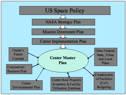
Figure 1-1 The Center Master Plan's Role in NASA Planning Process
1.2.4 The CMP is a vital management tool for predicting and managing costs for long-term projects that may involve many unknowns at their inception. NASA has an obligation to assess expected costs accurately. By understanding infrastructure risks and cost, NASA managers can continue to conduct their projects and programs in a manner that increases public trust and confidence.
1.2.5 The CMP provides a reference for review and approval of specific facility projects as part of the normal budget formulation and execution process. It also provides a basis for cooperative planning with other Federal, State, Tribal, Regional and local government agencies.
1.2.6 The CMP provides the context and basis for all siting decisions for construction and demolition projects, as well as for relocation of functions at the Center. All construction and other facilities infrastructure projects must be consistent with the CMP.
1.3.1 This NPR contains NASA procedural requirements for Center master planning for real property. This NPR includes instructions for accomplishing the master planning process, as well as specifying the required content of a CMP.
1.3.2 Each Center and component facility shall develop and maintain a CMP. The CMP is a living document and shall be kept current with changes to the Center's mission, facilities and infrastructure. The CMP shall be prepared in accordance with NPD 8810.2, Master Planning for Real Property.
1.3.2.1 The CMP shall address a planning horizon of not less than 20 years.
1.3.3 The NASA Center Director is responsible for approving and signing the Center's Master Plan. This responsibility cannot be delegated.
1.3.3.1 The Center Director is to designate a specific organizational element to be responsible for maintaining the CMP at the Center.
1.3.4 The Center Director is to conduct periodic reviews, at not less than 3-year intervals, of the master plan in order to validate the CMP and to ensure that the Center's missions and objectives are adequately translated into the CMP.
1.3.4.1 Review and update of the Center's CMP must reflect the most current projections for the Center's Capital Improvement Plan.
1.3.4.2 A verification letter of the 3-year review, validating the CMP as current with the Center mission, is to be maintained with the CMP.
1.3.5 The Center Director must provide the draft Center's CMP to the Director, Facilities Engineering and Real Property Division and the appropriate Headquarters Center Executive, for review and concurrence by NASA Headquarters whenever newly prepared, or significantly modified. The Center shall present the CMP to these headquarters offices during development of the CMP so these headquarters offices may aid in establishing the direction and development of the CMP.
1.3.5.1 NASA Headquarters Facilities Engineering and Real Property Division will notify the Center Director within 30 days of any outstanding issues regarding the CMP or will provide concurrence with the CMP to the Center Director within that time period.
1.3.5.2 NASA Headquarters concurrence of a CMP shall not be construed as approval of any specific facilities project identified within the CMP.
1.3.6 A critical review of each NASA Center CMP will be performed by NASA Facilities Engineering and Real Property Division and the appropriate Headquarters Center Executive every three years from adoption of a newly prepared or significantly modified CMP. This review will be undertaken to determine whether the CMP addresses the NASA Strategic Plan, the NASA Asset Management Plan for real property, Directorate Strategy, current NASA policies and guidance, statutory and regulatory requirements and other Federal Government performance objectives.
1.3.6.1 The Director, Facilities Engineering and Real Property Division will coordinate the CMP review with all other Mission Directorate and Mission Support Offices, and management officials, as appropriate.
1.3.6.2 The Facilities Engineering and Real Property Division will provide a report to the Center Director on the outcome of the review. The report is to delineate issues and concerns found during the course of the review.
1.3.6.3 The NASA Asset Management Plan for real property has been developed in response to Executive Order 13327, "Federal Real Property Management." The NASA Asset Management Plan for real property is the primary document for overall management of NASA real property including all constructed assets, i.e., buildings, utilities, runways, etc.
1.3.7 An agency-wide capital plan will be developed by the Facilities Engineering and Real Property Division based on the Centers' Capital Improvement Plans and the NASA Asset Management Plan for Real Property.
1.3.7.1 The agency-wide capital plan shall be maintained by the Facilities Engineering and Real Property Division, and updated annually to reflect changes to the Center Capital Improvement Plans (CIP) that reflect current projects and changes to out-year projects and proposals.
1.3.7.2 The Center's Capital Improvement Plan (CIP) shall be maintained by the Center to prioritize and track the Center's 5-year plan for facility modification and improvement. The Center shall update its CIP annually to reflect current projects and changes to out-year projects and proposals.
2.1.1 Each Center shall develop the CMP through the following phased process. The phased approach allows the CMP to be based on consideration of the current capabilities of the Center to support its mission as well as developing alternatives to ensure the Center is able to support future requirements.
2.1.1.1 Exploration - Exploration is a process that aids in the Center determining its direction and needs. The Center is to consider future potential endeavors by NASA and determine if they are within the Center's capabilities. The Center needs to establish its goals to support its view of the future including goals of stakeholders (internal and external) that might be different from the Center's goals.
2.1.1.2 Validation - Validation involves establishing, at the start of the planning process, a current assessment of the Center, its mission, the Center's assets, and the assets of the surrounding community that are used to achieve the mission, and the values important to the Center.
2.1.1.3 Hypothesis and Testing - This phase involves the development and test of various alternatives for development of the Center. What alternatives are to be considered to achieve the future concept for the Center? It may be necessary to forecast future demand for the Center's products and services, or perform market analyses to establish possible alternatives to be considered. Use models to compare the costs and benefits of the various alternatives being considered. (For example, life cycle cost analysis.)
2.1.1.4 Primary Development Concept - Establish consensus on the future development of the Center to be depicted in the CMP.
2.1.1.5 Development Strategy - Prepare plans for achieving the primary development concept, identify the timeline or phases necessary to achieve the primary development concept. The proposed plans are to reflect the best current thinking about facilities engineering, life-cycle cost, sustainability, and aesthetics.
2.1.1.6 Safety and Mission Assurance Planning - All strategic planning shall include a risk identification and initial risk assessment as an overt part of the planning process. Mitigation and elimination of the identified risks shall be included in the planning process.
2.2.1 The master planning process begins with the Exploration phase to establish the concept of the Center's future. The future concept for the Center needs to be well documented and have senior management endorsement before it can be translated into a master plan.
2.2.2 The Center's future concept shall contain the Center's goals and objectives and shall articulate the overall strategy for:
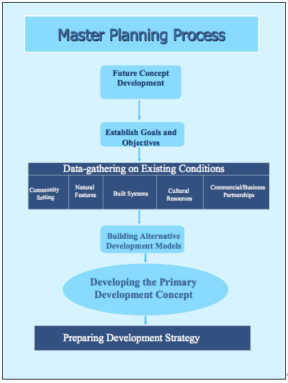
Figure 2-1 The Master Planning Process
2.2.3 As the first step in developing the CMP, the Center Director shall establish a CMP Steering Group composed of individuals from the senior leadership of the various components at the Center to establish the future concept of the Center through the Exploration phase. The CMP Steering Group is to develop a broad concept of the Center's future, and the steps necessary to achieve it. The Steering Group will:
2.2.3.1 The Steering Group must include representatives from the major programs supported at the Center, as well as a representative from the Center Facilities Office and the Center Planning Office. The Steering Group will develop a Center Master Planning team composed of planners, stakeholders, and technical experts to develop the data and construct the models for the CMP.
2.2.4 The future concept for the Center must be consistent with NASA's Strategic Plan, NASA's Strategic Real Property Plan, Mission Directorate Plans, and the Center's Implementation Plan (see Figure 2-1). The future concept of the Center shall be based on an integrative approach that considers the synergy between natural features and built systems. This integrated approach shall be used in defining the primary concept for future develpment and alternative development models.
2.2.5 The type of environmental analysis required and the timing of that analysis is to be determined early in the CMP process and in consultation with the Center Environmental Management Office and in accordance with existing NASA policy. Each Center is required by NASA regulations to maintain an Environmental Resources Document (ERD). The ERD can be a valuable tool in the CMP process since it identifies areas of environmental and cultural resource sensitivity.
2.2.5.1 The NEPA and environmental review process is not limited to the primary development concept alone. Sufficient information must be gathered on reasonable alternatives to permit a meaningful comparison among the alternative concepts thereby providing a clear basis for choice among options by the NASA decision maker and the public. The process described in this guide for developing and testing alternatives will provide information for this comparison.
2.2.6 Following the Exploration phase and preparation of the Center's future concept and the goals and objectives, the Steering Group shall oversee the collection and analysis of data during the Validation phase. 2.3 Validation - Data Collection and Analysis 2.3.1 A considerable amount of data must be collected and analyzed to support the efforts of the Steering Group during the Validation phase. The analysis of the data will aid in the development of the alternatives, as well as in the preparation of the CMP. Much of this data resides in existing databases or may be contained in the current master plan.
2.3.2 An analysis of the collected data is necessary to determine the significance of current and projected conditions on the future concept for the Center. Proper analysis will define how current and projected conditions will affect future development and how improvements can be made to meet future needs.
2.3.3 The data shall be collected in two broad categories:
2.3.3.1 Community Setting and Natural Features. The Center's geographical location and physical relationship to adjoining jurisdictions are examined in terms of regional conditions and trends. This examination shall include the following:
2.3.3.2 Existing Conditions and Built Systems. Existing natural and man-made conditions on the Center.
2.5.1 With the data and analysis from the Validation phase, the Center is prepared, during the Hypothesis and Testing phase, to create the alternative development models that can achieve the Center's future concept developed during the Exploration phase.
2.5.1.1 The CMP Steering Group shall:
2.5.1.2 The following factors shall be considered in the development of the alternative development models:
2.5.1.3 Identify the functional relationship of activities at the Center. The identification of existing functional relationships at the Center requires an analysis of the broad range of organizations and activities at the Center and the natural flow that takes place between these activities or organizations. Functional relationships exist where there are dependencies between organizations and activities at the Center. A functional dependency exists where the efficient performance of an activity within one area of the Center depends on maintaining or enhancing the flow of activity that originate, continue, or conclude in another area. Conversely, there may be activities that are incompatible and need to be physically separated from each other.
2.5.1.4 Functional relationships can be graphically depicted to enable the preparers of the concept models to better understand the dynamics of the Center's activities (See figure 2-2). For some Centers, the complexity of activities may need to be shown in several separate graphical depictions.
2.5.1.5 Specific consideration shall be given to the following broad functional relationships:
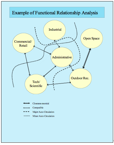
Figure 2-2 Example of Functional Relationship Analysis
2.5.2 Alternative development models describe specific functional relationships as well as the spatial arrangement of the Center's real property assets that can support a specific view of the Center's future development. Alternative development models are to depict logical arrangements for the Center's real property assets that best represent the ideal spatial relationship of the facilities to support the specific alternative being considered. Different alternatives allow for comparison of the various tradeoffs considered in choosing the primary development concept.
2.5.2.1 The following five elements are to be addressed in the alternative development models.
2.5.3 The alternative development models are to be analyzed and tested to determine which is the most effective in reaching the Center's future concept. This analysis involves comparing an ideal functional arrangement with the existing physical constraints and opportunities at the Center. Alternative development models are to be tested against their ability to achieve the Center's future concept, goals and objectives. The following criteria shall be used in developing and comparing alternative development models:
2.6.1 A Primary Development Concept is derived from the alternative development models that are built and tested by the CMP Steering Group. The Center's primary development concept is the best of the alternatives tested. It may be chosen one of the various alternatives tested, or it may consist of the best elements from several of the alternatives available.
2.6.2 Throughout the development of the alternative development models and in the development of the primary development concept, the need for an environmental analysis of any resultant major actions such as reduction or increase of operations or construction of facilities needs to be considered. It is imperative that the Center Environmental Management Office be consulted throughout the process to ensure that the correct level of analysis is performed and the environmental analyses are begun and completed at the appropriate times.
2.6.3 Sustainable design principles must be incorporated into the primary development concept to reduce life-cycle costs. The essential elements of NASA's sustainable design principles are found in NPD 8820.3, Facility Sustainable Design.
2.6.4 Design principles for all facilities and infrastructure shall include elements necessary to meet applicable codes and regulations including the Americans with Disabilities Act. NPR 8820.2E, Facility Project Implementation Guide, and associated directives/regulations address these and other necessary design considerations.
2.7.1 The Development Strategy consists of the proposed plans for achieving the primary development concept, as well as identifying the timeline or phases necessary to achieve the primary development concept. The proposed plans are to reflect the best current thinking about facilities engineering, life-cycle cost, sustainability, as well as aesthetics.
2.7.1.1 The preparation of the Development Strategy and the specific Centers projects and other major actions will require an environmental analysis at the appropriate time. The Center is to have made a determination of the type and timing of environmental analysis early in the CMP process. That determination and any follow-on decision on environmental analysis must be made through consultation with the Center Environmental Management Office and in accordance with existing NASA policy.
2.7.2 The CMP Development Strategy is to identify the highest priority projects that are required to develop the Center in accordance with the primary development concept. These projects include facility construction and demolition as well as utility and infrastructure changes.
2.7.2.1 Projects are to be grouped in related sets by fiscal year that accomplish the development objectives of the primary development concept. The projects are to be prioritized and sequenced for construction or demolition within succeeding five year periods from adoption of the CMP.
2.7.2.2 Prioritization is to include the extent to which the project carries out a specific objective identified in the CMP. In this regard, analyze the following questions:
2.7.2.3 A Mission Dependency Index (MDI) may be utilized to evaluate the criticality of the current and planned facilities at the Center. A MDI is an operational risk management assessment used to rank the criticality of facilities at an installation. Identifying critical facilities will assist in prioritizing new construction needs as well as identifying necessary maintenance and repair investments.
2.7.2.4 The Development Strategy is to identify proposed funding sources to accomplish the identified projects.
2.7.3 The CMP Development Strategy is to be updated annually, to reflect the projects that have been previously implemented and those that remain necessary to achieve the primary development concept.
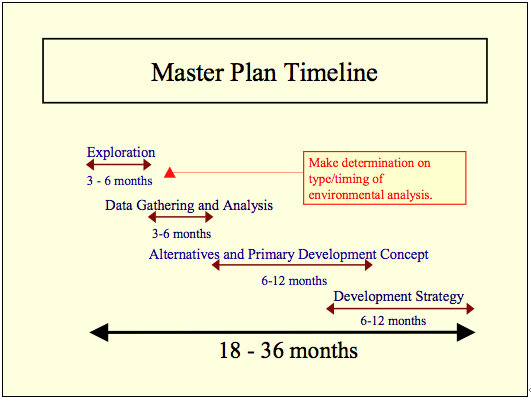
Figure 2-3 Master Plan Development Timeline]
The planning process described in the previous chapter culminates in a Center Master Plan (CMP). The CMP is based on the primary development concept, outlines the characteristics of the desired end-state of the Center, and identifies the goals and objectives necessary to reach the desired end-state. As such, the CMP consists of both narrative sections and a series of maps and/or plans that depict existing and planned future conditions for the Center, as well as an interrelationship and/or linking to existing databases.
3.1.1 The following listed sections and sub-sections are the required format for all CMPs. These sections and sub-sections may be augmented by others at the Centers' discretion. The sections of the CMP shall be arranged as shown Figure 3-1.
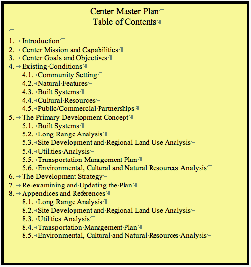
Figure 3-1 Master Plan Table of Contents
3.2.1 The information contained in the on-line CMP is to be easily accessible by a diverse audience, and at a reasonable cost. Accordingly, CMPs must be prepared to be electronically retrievable and web-based, using the structure specified in this section.
3.2.2 The online CMPs must follow current IT security procedures. Security concerns for CMPs include defining levels of access and determining what parts of the CMP will be available at each of the levels of access. There may be multiple levels of access such as that available to the public, that which is available to all Center employees, and a level at which information is more restricted. This last level may be for individuals who are allowed to open links to data that is available on a need to know basis. These levels might restrict who can view maps on-line, specific facility information on-line, or information related to personnel assignments.
3.2.3 The on-line CMP is to have a home page providing the effective date, certification information, and a contents section or page with appropriately identified links to each of the sections defined in Chapter 3 of this guide, "The Master Plan."
3.2.4 The CMP may provide links, or portals, to other databases containing the information and graphics that underlie the master plan.
3.2.4.1 Links to pages containing information beyond the requirements of Chapter 3 of this Guide are to be appropriately identified.
3.2.4.2 Links to information sources outside of NASA shall be tagged as an external link.
3.2.5 Web-enabled CMPs must comply with Section 508 of the Rehabilitation Act and meet accessibility requirements.
3.2.6 The on-line CMP format is to provide for general usability by NASA personnel with standard desktop software.
3.2.6.1 Viewing, printing, or downloading sections of the CMP ought not to require license to software beyond the NASA standard desktop suite. Any helper software determined to be essential for optimal use of the CMP site is to be available for download from the CMP's on-line site.
3.2.6.2 All narrative material shall be downloadable as, or readily convertible to, word processor files in the NASA standard desktop suite.
3.2.6.3 All tabular material shall be downloadable as, or readily convertible to, spreadsheet files in the NASA Standard desktop suite, or downloadable as a pdf file.
3.2.7 A specific Center organizational element is to be identified for the responsibility for overall maintenance and updating of the on-line CMP.
3.2.7.1 There is to be a certification of the accuracy of the CMP by Center Management based on the interval established by the Center in the CMP, but not at intervals greater than three years. For certification of individual pages or selected data elements that are more rapidly overtaken by events, provision for delegating responsibility to the lowest feasible management level is recommended.
3.3.1 Computer Aided Design/Geographic Information Systems (CAD/GIS) must be used to display land use plans, floor plans, equipment plans, utility systems, transportation management plans, etc., or any other spatial data contained in the information systems listed in Section 3.1. All GIS (or CAD systems) shall comply with NASA guidance and the following standards:
3.3.2 CAD Drawings and Data: CAD drawings and data used for the planning, design, construction, operations, maintenance and demolition of NASA facilities and installations shall be delivered in conformance with the latest version of the following standards and policies:
3.3.3 Mapping. Cartographic design is very different from technical drawing. The purpose of a map is not to show everything to the greatest detail, but is to allow the user to gain spatial knowledge. Therefore, with maps specific concern and features may be stressed or they may merely serve as background for orientation. Major benefit of a map is that it organizes and presents data in the following manner to:
3.3.3.1 For each map the visual hierarchy must be established. The visual hierarchy is used to determine the key design features for the map as well as the focus of the map and how to make these focus features clear to the user. The hierarchy is supported by decisions regarding color, and text, and symbology to ensure the map is well suited to the structure of the CMP and will speak effectively to its users.
3.3.3.2 It is important to use symbology that is familiar both to the cartographer and the user. This includes symbols in CAD drawing standards. If the map is to convey spatial understanding, then the important features of the map must be apparent and other features are less dominant.
3.3.3.3 Color conventions and other visual attributes for maps must be standard throughout the CMP. Conventions and symbols must be clearly defined within the document so that the user is able to quickly find and understand the conventions used. Generally accepted mapping conventions are to apply; i.e., a map is not to have blue land and pink water.
3.4.1 Master planning is an iterative process in which a completed CMP is continually reassessed to determine whether the plan is achieving the goals originally established at the outset of the planning process. In addition, a change in mission or other conditions may require a re-examination of the goals to be achieved by the CMP. If a CMP is to remain relevant, it must be flexible and adapt to change. The following circumstances may dictate a reexamination of the CMP at an interval sooner that those described in Section 1.3.6:
3.4.2 Accordingly, the CMP shall contain a section in which the Center's process for updating or otherwise revising the CMP is described.
3.4.2.1 The process for review and change to the CMP is to include one of the following: