Chapter 3. The Master Plan
The planning process described in the previous chapter culminates in a Center Master Plan (CMP). The CMP is based on the primary development concept, outlines the characteristics of the desired end-state of the Center, and identifies the goals and objectives necessary to reach the desired end-state. As such, the CMP consists of both narrative sections and a series of maps and/or plans that depict existing and planned future conditions for the Center, as well as an interrelationship and/or linking to existing databases.
3.1 Organizing the Center Master Plan
3.1.1 The following listed sections and sub-sections are the required format for all CMPs. These sections and sub-sections may be augmented by others at the Centers' discretion. The sections of the CMP shall be arranged as shown Figure 3-1.
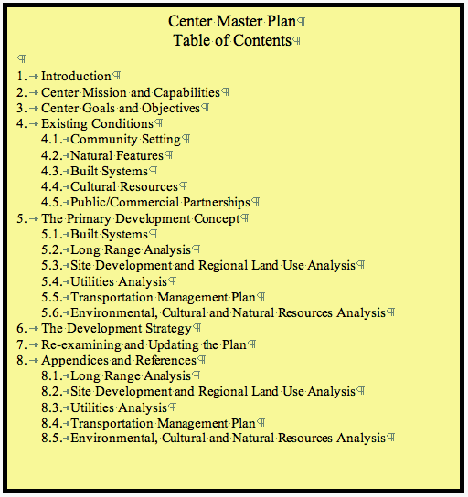
Figure 3-1 Master Plan Table of Contents
- Introduction. (CMP Section 1) This section provides an overview of the planning process and approach used in building the CMP, as well as identifying the office that participated in the planning process. The Center's future concept and associated goals and objectives established for the CMP are presented. This section also describes how the CMP incorporates and reflects the Center's Implementation Plan and program goals, as well as Mission Directorate Plans.
- Center Mission and Capabilities. (CMP Section 2) This section describes the Center's history, as well as describes the mission and capabilities of the Center and the Center's relationship to missions performed by Component Facilities and other NASA Centers.
- Center Goals and Objectives. (CMP Section 3) This section outlines the Center's goals and objectives and includes a brief synopsis of the primary development concept and how it provides a structure for Center development.
- Existing Conditions. (CMP Section 4) The Existing Condition section includes the sub-sections described below as well as pertinent Center statistical data, such as the number of employees (both government and contractor employed), acreage, building, and structure square footage, etc.
- Community Setting. (CMP Section 4.1) This section is to provide a discussion of adjacent land use; availability of adjacent land for expansion; effect of Center on traffic and public transportation; availability of housing, schools, churches, and recreational facilities for NASA personnel; zoning regulations affecting the Center and coordination with local and regional planning agencies, state Departments of Transportation, homeowners associations of adjacent neighborhoods, and historical sites or districts. The section is to include maps, such as those illustrating adjacent areas, regions, and properties affecting the Center such as local communities, highways, airports, hospitals, adjacent facilities, and floodplains.
- Natural Features. (CMP Section 4.2) This section provides a discussion of geology and metrological conditions as they affect programs of the Center and the design of facilities. Existing provisions for floodplains and wetlands management and any other appropriate areas of environmental management is included in this section.
- Built Systems. (CMP Section 4.3) This section is presented as series of required sub-sections. The information in this section is to be incorporated in a GIS compatible format. This will allow visual display of the information as well as the ability to layer the information for review and analysis. Herein lies the strength of a GIS compatible CMP. GIS allows the maps to contain numerous layers, and gives Center personnel the ability to view individual or multiple layers, depending on the specific view required. Sub-sections that are required in this section are:
- Buildings and Structures. (CMP Section 4.3.1)
- Buildings and Structures Tabulation. The NASA Real Property Inventory (RPI) is to be the database for recording basic facility data. Information on existing buildings and structures must be kept up-to-date and maintained in the RPI.
- Supplementary Data. Additional information relating to existing facilities may be complied and tabulated by the Center to meet its needs.
- Utilities, Communications Systems and Environmental Facilities. (CMP Section 4.3.2) This section is to be a narrative and graphic presentation of existing power, lighting, heating, gas, communications, water and chilled water distribution, and other utilities. The section is to include solid waste management units; underground storage tanks; above ground storage tanks; permitted discharge points; treatment storage and disposal facilities; sites and facilities undergoing or requiring environmental restorations. Special note should be made of community or commercial interfaces.
- Transportation Systems and Improvements. (CMP Section 4.3.3) A narrative and graphic presentation of the existing Center road network, access roads, parking arrangements, runways, rail transportation (passenger and freight), heliports, waterways, and wharfage. Special note should be made of local community interfaces.
- Campus Amenities and Landscape Design. (CMP Section 4.3.4) A narrative and graphic presentation of the existing landscape design program, and conservation measures including water, energy, and erosion control, floodplain management, wetlands, coastal zone management, habitat and threatened/endangered species protection, and enhancement of natural beauty. Center informational signage is to be included in this sub-section.
- Emergency Response, Safety, and Security Management. (CMP Section 4.3.5)
- A narrative and graphical representation of existing emergency response, safety and security management arrangements are included in this sub-section. Identify areas and facilities containing explosives, propellants and pyrotechnics or other items with explosive capacity, radioactive or biohazards, including applicable quantity/distance requirements, in accordance with NASA requirements.
- Identify buildings with security alarms; emergency and/or fallout shelters, indicating shelter capacity; emergency power; medical facilities; fire protection and industrial safety; and any other appropriate protective arrangements.
- Cultural Resources. (CMP Section 4.4) This section contains a narrative and/or graphic presentation of the historical and archeological resources on the Center and in local area. It also includes properties listed or eligible for listing in the National Register of Historical Places.
- Public/Commercial Partnerships. (CMP Section 4.5) This section contains a narrative and/or graphic presentation of the commercial ventures at the Center, including, but not limited to the Visitor Center, research parks, other tourism activities and facilities, etc. Also included in this section are any tenant agencies and any buildings or other structures not owned by NASA such as contractor facilities on the Center.
- The Primary Development Concept. (CMP Section 5) The Primary Development Concept presents, in both narrative and graphic fashion, the plans for the Center at a selected time period in the future. It documents the Center's capabilities, constraints, criteria and opportunities for development. This section is to discuss the sustainable design principles incorporated into the changes and development at the Center. Integration of sustainable design principles incorporated into individual projects will also be discussed in the Development Strategy. The Primary Development Concept serves as the template for the future development of the Center's infrastructure to enhance the Center's mission and improve the quality of life of the Center's employees. The Primary Development Concept is both flexible enough to respond to future unforeseen needs without losing its foresight, yet detailed enough to clearly convey the appropriate spatial and functional relationships for the Center.
- The information related to the Primary Development Concept is to be incorporated in a GIS compatible format. This will allow visual display of the information as well as the ability to layer the information for review and analysis. Herein lies the strength of a GIS compatible CMP. GIS allows the maps to be developed with numerous layers, and gives Center personnel the ability to view individual or multiple layers, depending on the specific view required.
- This section may also include a presentation of alternative development models that were analyzed during the planning process, but were rejected.
- The information in the listed sub-sections is to describe the required changes from the Existing Conditions to achieve the Center's future concept.
- Built Systems. (CMP Section 5.1) This section, essentially, comprises the Center's Capital Improvement Plan and must reflect the most current projections for the Center's 5-year plan for facility modification and improvement.
- Buildings and Structures. (CMP Section 5.1.1) This section includes (1) Buildings and Structures Tabulation and (2) Supplementary Data.
- Utilities, Communications Systems and Environmental Systems. (CMP Section 5.1.2)
- Transportation Systems and Improvements. (CMP Section 5.1.3)
- Campus Amenities and Landscape Design. (CMP Section 5.1.4)
- Emergency Response, Safety and Security Management. (CMP Section 5.1.5)
- Long Range Analysis. (CMP Section 5.2) This section is to describe the Center's ability to support its current mission and to support future changes in that mission by identifying the capabilities and constraints of the Center. Finally, the Long Range Analysis is to establish the intermediate planning horizons that are contained in the Development Strategy (Section 6), leading to the farthest horizons of the CMP.
- Site Development and Regional Land Use Analysis. (CMP Section 5.3) This sub-section describes optimum land use relationships and incorporates all known constraints and opportunities. This section of the CMP will greatly benefit from the use of GIS. This section includes the following, as applicable:
- Discussion of grouping and/or separation of facilities to meet land use category requirements. Land-use plans, including planning constraints maps and functional relationship diagrams, shall show existing and proposed areas for these same categories as well as any others included by the Center. The land use plans and maps are to be GIS compatible. Those Centers with an airfield shall prepare an airfield-use plan containing an analysis of land-use compatibility problems and potential solutions in accordance with Government Services Administration (GSA) Federal Management Circular 75-2, Compatible Land Uses at Federal Airfields.
- A narrative and graphic delineation of temporarily unusable land, including areas out-leased or under permit; land subject to easement; in-leased land; and plans for acquisition or disposal of land.
- A graphic depiction (utilizing GIS/CAD technology), of the landscaping and conservation plans for the Center. The landscaping and conservation plan is to be presented separately from the site development plan.
- Utilities Analysis. (CMP Section 5.4) This subsection describes (in both narrative and graphic fashion), the capacities and limitations of the existing utility systems, as well as depicting improvements needed to meet the Center's future missions.
- Transportation Management Plan. (CMP Section 5.5) This section is to describe the goals and objectives of the transportation management plan and to depict how the future Center transportation network will be laid out and works to support the Center's mission. It will also depict how the Center's transportation management plans links up with the neighboring communities' transportation management systems.
- Environmental, Cultural and Natural Resources Analysis. (CMP Section 5.6) This sub-section identifies areas of environmental, cultural and natural resources concerns and constraints on the Center. This section is not intended to duplicate the Center's Environmental Resource Document (ERD), rather it is to discuss the relation between the ERD and the actions required to implement the primary development concept. This section is to contain an environmental overlay that graphically depicts the environmental conditions at the Center.
- The Development Strategy. (CMP Section 6) This section presents in both narrative and graphic (GIS compatible) format the plan for implementing the primary development concept. The phasing of proposals to implement the primary development concept is to be included in matrix or tabular format in five-year phases. The section is to contain a discussion of plans for currently approved, as well as proposed future new construction, alteration, conversion, rehabilitation, replacement, enlargement, extension, or demolition of buildings and structures necessary to implement the primary development concept. The sustainable design principles incorporated into each of the projects are to be discussed. Projects shall be grouped by function, land-use areas, or other appropriate categorization. Ecology and environmental sensitivity (as described in the Center's Environmental, Cultural and Natural Resources Analysis) that may be affected by the development shall be identified.
- Phasing. (CMP Section 6.1) The projects necessary for implementation of the primary development concept are to be listed for the current 5-year plan, i.e., the Center's Capital Improvement Plan (year by Fiscal Year), and grouped in 5-year increments beyond the current 5-year plan (years 6-10, years 11-15, years 16-20, etc.). Projects in the current Center's Capital Improvement Plan which are the most current projections for the Center's 5-year plan for facility modification and improvement are to be depicted, using electronic layering through GIS/CAD technology, to show proposed development in successive five year increments. This section must be updated annually.
- Re-examining and Updating the CMP. (CMP Section 7) This section is to describe the process that the Center will utilize in conducting the required reviews and necessary updates to its Master Plan.
- Appendices and References. (CMP Section 8) Listing of the repositories or offices of record for each type of basic document (including record drawings) having a direct bearing on the master plan. It is beneficial for the CMP to contain portals linking the CMP to these sources of information. Environmental analysis documentation is included in this section.
3.2 Format (Guidelines for Online Master Plans)
3.2.1 The information contained in the on-line CMP is to be easily accessible by a diverse audience, and at a reasonable cost. Accordingly, CMPs must be prepared to be electronically retrievable and web-based, using the structure specified in this section.
3.2.2 The online CMPs must follow current IT security procedures. Security concerns for CMPs include defining levels of access and determining what parts of the CMP will be available at each of the levels of access. There may be multiple levels of access such as that available to the public, that which is available to all Center employees, and a level at which information is more restricted. This last level may be for individuals who are allowed to open links to data that is available on a need to know basis. These levels might restrict who can view maps on-line, specific facility information on-line, or information related to personnel assignments.
3.2.3 The on-line CMP is to have a home page providing the effective date, certification information, and a contents section or page with appropriately identified links to each of the sections defined in Chapter 3 of this guide, "The Master Plan."
3.2.4 The CMP may provide links, or portals, to other databases containing the information and graphics that underlie the master plan.
3.2.4.1 Links to pages containing information beyond the requirements of Chapter 3 of this Guide are to be appropriately identified.
3.2.4.2 Links to information sources outside of NASA shall be tagged as an external link.
3.2.5 Web-enabled CMPs must comply with Section 508 of the Rehabilitation Act and meet accessibility requirements.
3.2.6 The on-line CMP format is to provide for general usability by NASA personnel with standard desktop software.
3.2.6.1 Viewing, printing, or downloading sections of the CMP ought not to require license to software beyond the NASA standard desktop suite. Any helper software determined to be essential for optimal use of the CMP site is to be available for download from the CMP's on-line site.
3.2.6.2 All narrative material shall be downloadable as, or readily convertible to, word processor files in the NASA standard desktop suite.
3.2.6.3 All tabular material shall be downloadable as, or readily convertible to, spreadsheet files in the NASA Standard desktop suite, or downloadable as a pdf file.
3.2.7 A specific Center organizational element is to be identified for the responsibility for overall maintenance and updating of the on-line CMP.
3.2.7.1 There is to be a certification of the accuracy of the CMP by Center Management based on the interval established by the Center in the CMP, but not at intervals greater than three years. For certification of individual pages or selected data elements that are more rapidly overtaken by events, provision for delegating responsibility to the lowest feasible management level is recommended.
3.3 CAD/GIS Standards
3.3.1 Computer Aided Design/Geographic Information Systems (CAD/GIS) must be used to display land use plans, floor plans, equipment plans, utility systems, transportation management plans, etc., or any other spatial data contained in the information systems listed in Section 3.1. All GIS (or CAD systems) shall comply with NASA guidance and the following standards:
- Spatial Data Standards developed by the CAD/GIS Technology Center for Facilities, Infrastructure and the Environment. These standards are harmonized with and extend the Federal Geographic Data Committee (FGDC) standards required by Executive Order 12906, dated April 11, 1994, "Coordinating Geographic Data Acquisition and Access: The National Spatial Data Infrastructure."
- FGDC Content Standard for Digital Geospatial Metadata (CSDGM). This FGDC metadata standard shall be used to document NASA facilities and land geospatial data.
- The CAD/GIS Technology Center's Guidelines for Installation Mapping and Geospatial Data shall be used for acquiring facilities, installation, and environmental mapping and geospatial data.
3.3.2 CAD Drawings and Data: CAD drawings and data used for the planning, design, construction, operations, maintenance and demolition of NASA facilities and installations shall be delivered in conformance with the latest version of the following standards and policies:
- U. S. National CAD Standard.
- CADD/GIS Technology Center AEC CAD Standard.
- International Alliance for Interoperability Industry Foundations Class Model (release 1.5 or above).
3.3.3 Mapping. Cartographic design is very different from technical drawing. The purpose of a map is not to show everything to the greatest detail, but is to allow the user to gain spatial knowledge. Therefore, with maps specific concern and features may be stressed or they may merely serve as background for orientation. Major benefit of a map is that it organizes and presents data in the following manner to:
- Quickly make sense of data.
- Identify and highlight patterns and trends.
- Focus attention on what is important and relevant.
3.3.3.1 For each map the visual hierarchy must be established. The visual hierarchy is used to determine the key design features for the map as well as the focus of the map and how to make these focus features clear to the user. The hierarchy is supported by decisions regarding color, and text, and symbology to ensure the map is well suited to the structure of the CMP and will speak effectively to its users.
3.3.3.2 It is important to use symbology that is familiar both to the cartographer and the user. This includes symbols in CAD drawing standards. If the map is to convey spatial understanding, then the important features of the map must be apparent and other features are less dominant.
3.3.3.3 Color conventions and other visual attributes for maps must be standard throughout the CMP. Conventions and symbols must be clearly defined within the document so that the user is able to quickly find and understand the conventions used. Generally accepted mapping conventions are to apply; i.e., a map is not to have blue land and pink water.
3.4 Re-examining and Updating the Center Master Plan
3.4.1 Master planning is an iterative process in which a completed CMP is continually reassessed to determine whether the plan is achieving the goals originally established at the outset of the planning process. In addition, a change in mission or other conditions may require a re-examination of the goals to be achieved by the CMP. If a CMP is to remain relevant, it must be flexible and adapt to change. The following circumstances may dictate a reexamination of the CMP at an interval sooner that those described in Section 1.3.6:
- A change in the Center's mission.
- Advances in technology that make possible the consolidation or dispersal of activities that could not have been previously considered.
- Significant changes occurring in the surrounding community.
3.4.2 Accordingly, the CMP shall contain a section in which the Center's process for updating or otherwise revising the CMP is described.
3.4.2.1 The process for review and change to the CMP is to include one of the following:
- An informal/continuous review by Center planners and stakeholders, possibly through an on-line bulletin board.
- An annual review, to insure that the budgeting for the real property program is consistent with the CMP's Development Strategy, including the Center's Capital Improvement Plan and other requirements of this NPR.
- A formal 3-year review, scheduled prior to the NASA Headquarters review, specified in Section 1.3.6 of Chapter 1.
DISTRIBUTION:
NODIS
This Document is Obsolete and Is No Longer Used.
Check the NODIS Library to access the current version:
http://nodis3.gsfc.nasa.gov
![[NASA Logo]](../Images/nasaball.gif)