Appendix B-2.
Mapping the Mishap Scene
1.1 Maps, Diagrams, Drawings, Charts, and Field Techniques
At the beginning of an investigation, the recording and measurement
of transient evidence is essential. In followup stages, engineering as-built
drawings can normally be used for reporting the extent and debris locations.
However, before adding transient measurements to as-built drawings, superfluous
detail should be removed; e.g., location of irrelevant sewer in a waste
management mishap. Facility drawings should be made available and accessible
to the investigator.
1.1.1 Maps.
1.1.1.1 Overall, small scale maps of longer distances and directions,
as well as large scale maps of the immediate scene will be useful. It is
on the latter that witness locations will normally be shown.
1.1.1.2 Measurements may be indicated by a reference point (angle and
direction), triangulation (two angles), or by using a grid.
1.1.1.3 Both fixed and transient evidence are important to the investigator
and can be recorded on maps. Fixed evidence includes landmarks and natural
features that will not move or deteriorate rapidly. Transient evidence
refers to any other evidence that may deteriorate rapidly or can be easily
removed or altered. The transient evidence to be recorded centers primarily
on two elements: (1) locations of wreckage and debris, and (2) locations
of persons (sometimes compiled on a separate witness map).
1.1.2 Diagrams.
1.1.2.1 Diagrams are arbitrary or stylized pictures of reality that
can show distribution or depict sequences, flows, or processes. Flow and
motion diagrams can include flow of energy, materials, plans, personnel;
etc. They are useful to the investigator in visualizing the flows and sequences
that were occurring, or should have been occurring, before, during, and
after the mishap. Diagrams may be existing or may have to be created by,
or for, the investigation board.
1.1.2.2 Diagrams of the mishap area, to scale, and indicating relative
positions of equipment, wreckage, bodies, obstructions, flight path (if
applicable), positions of witnesses, etc., should be prepared for study
during the investigation. Several methods may be used in plotting the area
diagram. The choice depends mostly upon terrain. These methods are as follows:
a. Grid. The grid consists of equal size squares, the scale and size
of which depends upon extent of wreckage scatter. Grid lines should be
laid off on ordinal compass headings, using surveyor's equipment or a compass
and tape. (Overlay or circular grid over square grid is useful in explosive
mishaps where a radial pattern of debris may be expected.) The grid should
be "anchored" at one corner to a permanent reference point and all grid
references taken from the corner. References to locations are then shown
as grid coordinates.
b. Straight Line Distance. A straight line is extended from a starting
point, usually the initial impact point, down the centerline of the wreckage
distribution. The centerline is marked in distance increments (feet, yards,
meters, etc.) to indicate distance from the initial point and all other
measures are taken at 90 degree angles to the central reference line. In
this case references are recorded as distance from the reference point
and distance from the centerline at 90 degree angles (60.5 feet/14.7 feet
right or East).
c. Distance and Heading. This method consists of plotting significant
wreckage parts by distance and degrees from a central or initial point,
normally the impact point. The presentation will be basically the same
as the grid system but will require a full time surveyor and may consume
more time.
d. Circular Plot. This is especially useful when there is a uniform
distribution of wreckage. The circular plot is referenced to a point at
the center of the mishap area. All references are then made as compass
headings from North and a distance from the center reference (137 degrees/
475.5 feet).
e. Vertical Photographs. Aerial photographs can be used to advantage
where wreckage is scattered over a great distance or where extreme terrain
problems exist. This type of vertical photograph is especially adaptable
in early coverage of a mishap involving hazardous material contamination.
f. Layout Plans or Photography. When mishaps occur in areas for which
drawings are available or where helicopter coverage is most convenient,
it is preferred that wreckage plotting be accomplished on layout plans
or with the aid of close range aerial photographs. Three dimensional (perspective)
drawings, cutaway drawings, and schematics may be useful for plotting areas
where depth cannot be shown by vertical drawings, maps, or photographs.
1.1.3 Drawings. These should be simplified pictures of reality, such
as manufacturing or construction prints, perspective drawings, cutaway
drawings, etc. Drawings can often be highlighted or captioned to call attention
to significant detail. The initial effort is to record only transient evidence
in a sketch roughly to scale. Do not measure locations of permanent fixed
objects. They can be located on copies of drawings at a later time.
1.1.4 Charts.
1.1.4.1 These may include photographic reproductions of records (e.g.,
temperature and pressure), trend analysis or types and classes (commonly
seen as "statistics"), and organization charts. For statistical charting,
the best advice is to consult a good statistician. However, two potential
problem areas are:
1.1.4.2 Do not use broken scales on charts. Possible exception: If a
variation of 1 or 2 percent in a factor is significant (i.e., a causal
factor), a broken scale chart to highlight the detail may be useful. Also,
if a single value would compress the scale so as to eliminate useful detail,
simply note it at the top with an arrow pointing up.
1.1.4.3 Do not connect discontinuous data with a trend line or use a
bar chart. Possible exception: When two or more profiles are being compared.
1.1.4.4 For organization charts, which should be a required exhibit
in most reports, the rule is to store complete organization charts in investigation
board files and use a report exhibit to show only relevant structures and
relationships such as: (1) the organizational chain from the mishap organization
manager up to the senior executive officer in the mishap organization and
to the ultimate chief executive officer if appropriate (for example, to
the NASA Administrator), and (2) to show organizational placement of major
functions, such as safety, quality, training, engineering, purchasing,
and maintenance. Factors of remoteness may be significant, either because
remoteness produced poor communications or remoteness affected the independence
or review. When maps, drawings, diagrams, and charts are used to record
evidence, note the same types of items which are applicable when making
photographs. Do not use more diagrams, drawings, and charts than absolutely
necessary. Unneeded charts can slow understanding.
1.1.5 Field Techniques.
1.1.5.1 The most versatile field tools the investigator has for mapping
and diagramming are his pencil and pad. Investigators do not need to be
world-class artists to be effective in the field. Care, diligence, and
attention to detail will provide excellent results and yield information
that will be valuable later. The two figures that follow show an evidence
record log (Figure B-2-1) and a drawing of a mishap scene (Figure B-2-2).
The drawing is used for relational perspective and the log supports it
with detail about each piece of evidence.
1.1.5.2 This approach keeps the drawing from being so cluttered that
information runs together. It also allows the investigator to keep drawings
of complex sites on a manageable size sheet of paper.
ááááááááááááááááááááááááááááááááááááááááááááááá
Completed by:áááááááááááááááááááááááááááááááááááááááááááááááááááááááááááááááááááááááááááááááááááááááááááá
Date:_________
ááááááááááááááááááááááááááááááááááááááááááááááá
NAME_________________
ááááááááááááááááááááááááááááááááááááááááááááááá
POSITION______________áááááááááááá
Instructionsáááááááááááááááááááááááááááááááááááááá
Time:_________
á
| Code # |
Object |
Reference Point |
Distance |
Direction |
|
1
|
Location of injured's feet (marked in chalk) |
N.E. corner of chamber 2560 |
4' 5" |
035 deg. |
|
2
|
Location injured's head (marked in chalk) |
N.E. corner of chamber 2560 |
10' 7" |
060 deg. |
|
3
|
Largest fragment of door |
N.E. corner of chamber 2560 |
8' 4" |
075 deg. |
|
4
|
Large fragment |
N.E. corner of chamber 2560 |
17' 6" |
155 deg. |
|
5
|
Gouge on wall |
N.E. corner of chamber 2560 floor |
14' 58" |
095 deg.up |
|
6
|
Outer limits of small debris |
N.E. corner of chamber 2560 |
5' 6" |
030 deg. |
|
7
|
Outer limits of small debris |
N.E. corner of chamber 2560 |
12' 5" |
045 deg. |
|
8
|
Outer limits of small debris |
N.E. corner of chamber 2560 |
18' 4" |
165 deg. |
|
9
|
á |
á |
á |
á |
|
10
|
á |
á |
á |
á |
|
11
|
á |
á |
á |
á |
|
12
|
á |
á |
á |
á |
Attach sketch on grid paper.
Figure B-2-1: MEASURING AND RECORDING TRANSIENT EVIDENCE
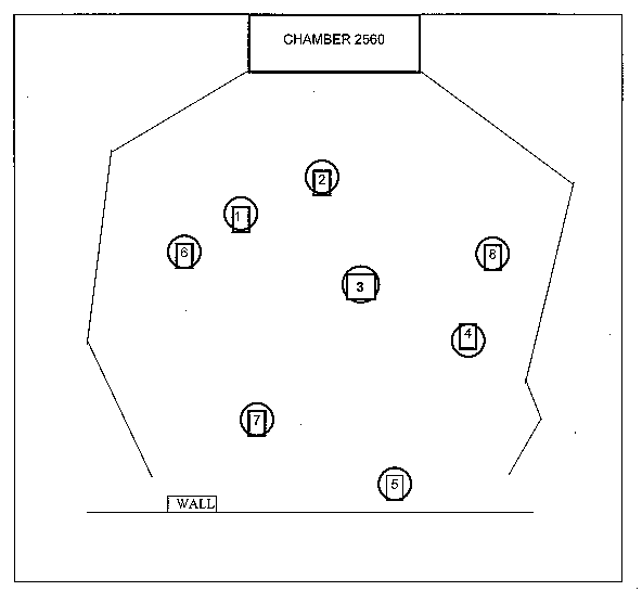 Figure B-2-2: DIAGRAM OF TRANSIENT EVIDENCE FOR MEASURING AND RECORDING
DISTRIBUTION:
NODIS
This Document is Obsolete and Is No Longer Used.
Check the NODIS Library to access the current version:
http://nodis3.gsfc.nasa.gov
![[NASA Logo]](../Images/nasaball.gif)